
Arches National Park features hundreds of hiking trails that go on for miles and miles that span the wonderland of red rocks and beautiful arches. With so many hikes that take you from an overview of the unforgettable vistas and views, from to the delicate arches that range in a few feet wide to a few hundred feet tall, this park has many unforgettable sights to see. The red rock arches against the blue Utah skies will have you wondering if you’re looking at a painting or real life.
We’ve gathered a list of the 12 short and easy hikes in Arches National Park that you can easily do during your trip.. With so many options it can be overwhelming, but we’ve slimmed it down so you get to hike the best of the best within this park. We can go on for days of the numerous hikes you should do, but time is limited and you have hikes to hike!
Arches National Park Overview
Arches National Park is located in the east side of Utah, just a short drive outside of the city Moab, Utah. Arches National Park is known for its out of this world arch formations that are scattered throughout the park and take on many unbelievable shapes and sizes.
This park features over 2,000 plus natural sandstone arches that have been formed over millions of years. Arches National Park is home to the infamous Delicate Arch that is on the Utah license plate and likely seen all over social media. Each hike you do to a new arch will leave you breathless as you will wonder how such beauty has formed and how it was even possible!
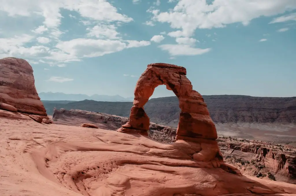
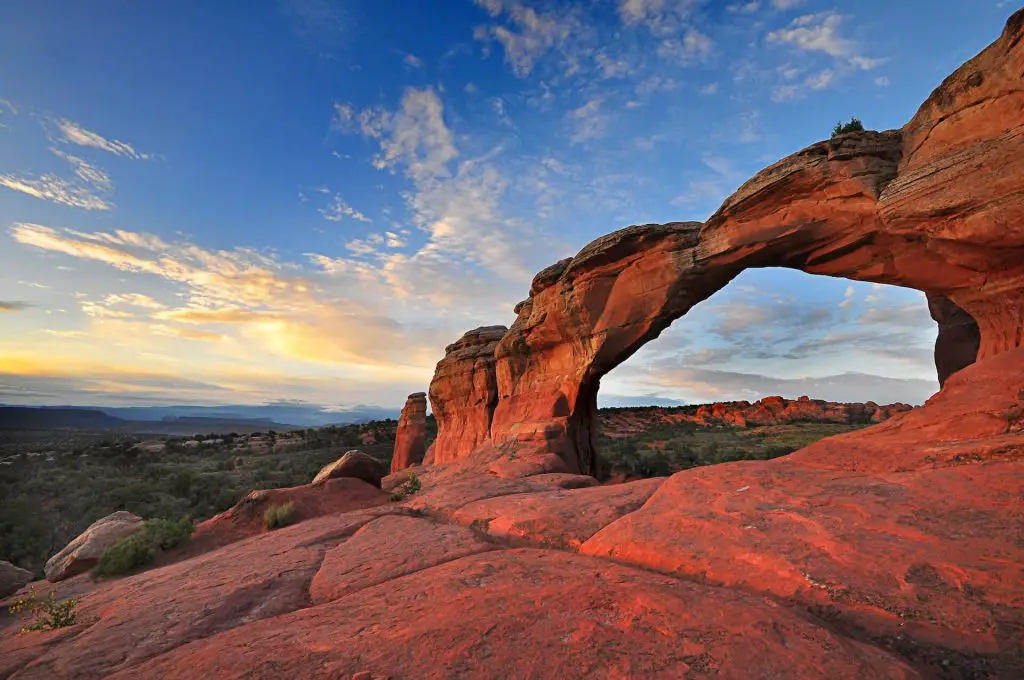
Delicate Arch
Distance: 3.1 Miles (round-trip)
Elevation: 610 Feet
Difficulty: Moderate
Duration: 2 to 3 hours
Trailhead: Wolfe Ranch Parking Lot
https://goo.gl/maps/Foew37z48o2w9tYCA
Trail Description:
This moderately difficult trail features the one thing most visitors picture when someone says Arches National Park, that is the Delicate Arch. When you finish the hike you won’t believe your eyes when you see the Delicate Arch in Person as it looks perfectly crafted and nearly man-made. The hike starts off in dessert terrain with a few stunted trees before you make your way over the rock slabs field. The last leg of this hike has a small rocky ledge you should be careful of until you reach the final platform before the Delicate Arch.
Keep in mind:
This hike is world famous which means there will be many other hikers. This hike also has virtually no shade, so it will be incredibly sun and hot. If you are hiking this in the Summer, be sure to bring plenty of water and take your time. If you are hiking this winter there are certain spots that can get icy so we recommend you bringing micro-spikes as the very last turn of the hike is relatively steep and can get super slippery. If you can time it we recommend hiking it during sunset or sunrise as you will get magnificent glow of colors on the majestic Delicate Arch.
Landscape Arch Trail
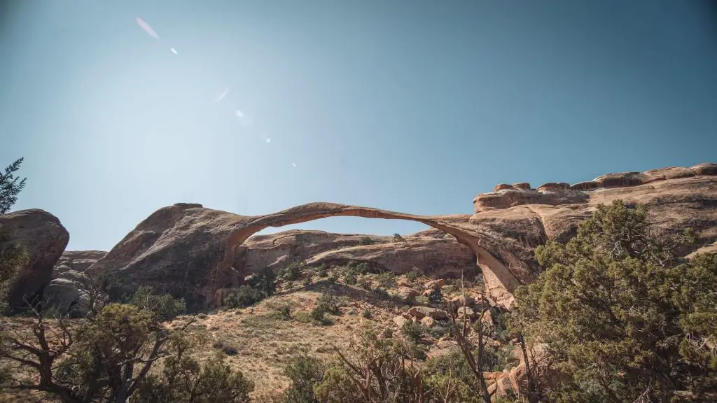
Distance: 1.9 Miles (round-trip)
Elevation: 259 feet
Difficulty: Easy
Duration: 2 hours
Trailhead: Devils Garden Trailhead
https://goo.gl/maps/sqCanwKNpzQSMJ54A
Trail Description:
Landscape Arch features the world’s largest sandstone arch which is an impressive 290 foot long sandstone arch that is a must see for visitors to Arches National Park. This hike is relatively flat with just small elevation gains on a few hills throughout the hike. This trail is well marked and well maintained. There is a split on the trail that breaks off to the Pine Tree Arch and the Tunnel Arch, however you can skip those and go for the main feature by continuing straight on the trail. The trail ends at the Landscape Arch viewing area where you will be in disbelief that something like this is still being held together.
Keep in mind:
This is one of the most popular hikes in the park, so expect many other hikers on the trail. This hike takes you to the front of the the arch, and there is no way to actually hike on the arch. This trail also has no sun cover and you will be exposed to the sun the entire time.
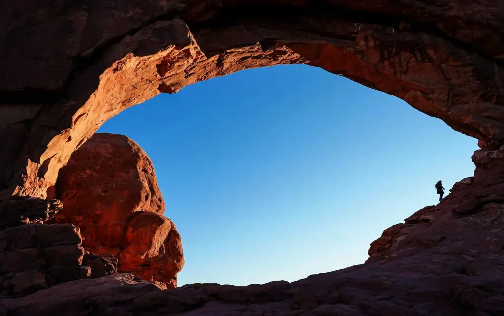
Partition Arch Trail
Distance: 2.8 Miles (round-trip)
Elevation: 470 feet
Difficulty: Moderate
Duration: 2 to 3 hours
Trailhead: Devils Garden Trailhead
https://goo.gl/maps/sqCanwKNpzQSMJ54A
Trail Description:
This trail features the amazing Partition Arch window, one of my favorite arches as the window is huge and provides another picture perfect frame of the vermillion Arches National park landscape. This hike was worth the challenge and should definitely not be missed. At the end of this hike you can walk right up to the arch and stand in the opening for great photos. From the trailhead its a standard hike on a well paved trail, however there is one tricky part. This hike requires a tough scramble up a slanted slick rock-face that is pretty high up with drop offs on both sides. . Once you complete this scramble the last section of this hike is on sandy gravel trail right before you reach the Partition Arch.
Keep in Mind:
This hike can be done in conjunction with other hikes in the Devil’s Garden. The toughest part of this hike is the slick slab of rock that you have to scramble up. There were certain parts that made me feel off balance. I would not hike this hike if it rains as that rock slab is very slippery even in dry conditions.
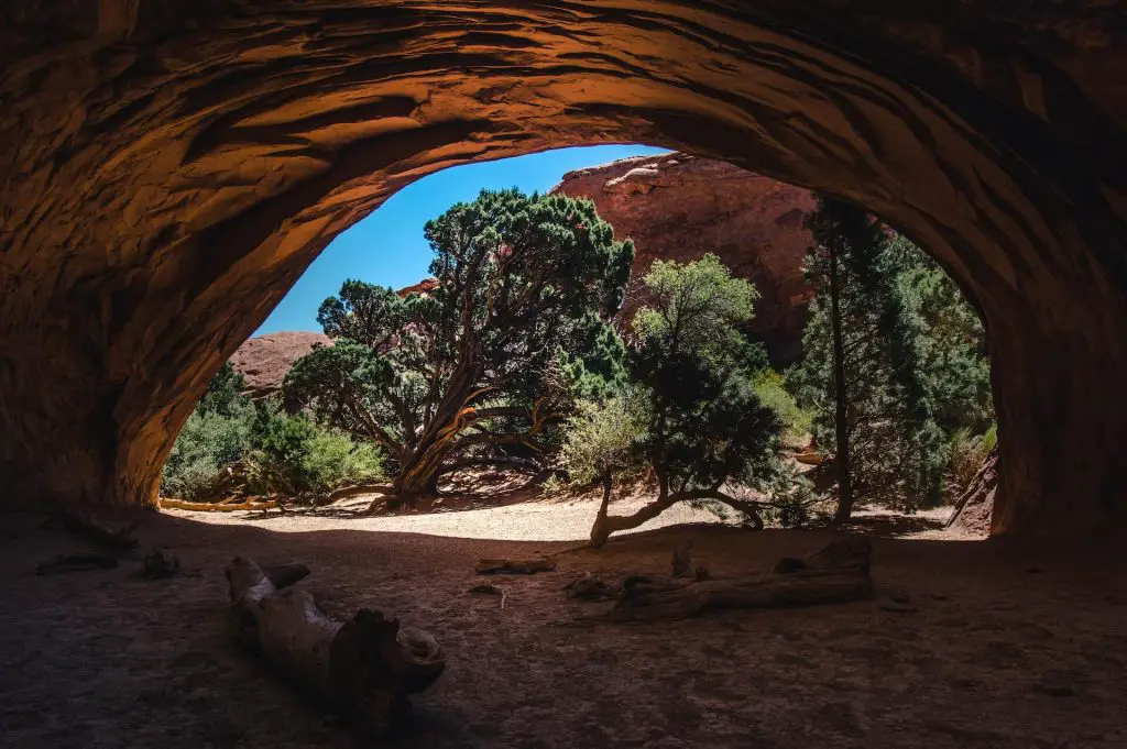
Navajo Arch Trail
Distance: 2.9 Miles
Elevation: 492 feet
Difficulty: Moderate
Duration: 2 to 3 hours
Trailhead: Devils Garden Trailhead
https://goo.gl/maps/sqCanwKNpzQSMJ54A
Trail Description:
This hike begins at the Devil’s Garden Trailhead and can be added onto the Landscape arch hike. This trail features an arch partition in the rock that looks like you are looking into a cave. The hike is relatively tame as you hike from the parking lot to landscape arch, but once you reach this point this is where things get a bit more adventurous. You will be required to scramble up very large slanted slick rock before the trail levels out and you reach the Navajo Arch.
Keep in mind:
This hike can also be added as a side hike part of the many arches available in the Devil’s Garden. The majority of this hike is just a normal walk on dirt, however there is one tricky spot where a major incline on slick rock takes place, so take your time as you scramble up the rock. If it is raining we advise you not to hike this hike as the scramble would be incredibly challenging on the incline. This trail also has minimal sun cover, so be sure to bring a hat and enough water.
Double Arch Trail
Distance: 0.5 miles
Elevation: 95 Feet
Difficulty: Easy
Duration: 30 minutes
Trailhead: Double Arch Parking Lot
https://goo.gl/maps/yEvfingcqHsDA68T6
Trail Description:
This short walk is just 0.5 miles from the Double Arch parking lot. This hike leads to a massive double arch that completely towers over you. This hike is an absolute must as this sight is something you’ve never seen before and will leave you wondering how such an amazing rock formation like this was formed. Once you reach the double arch, its just the same short walk back to the parking lot.
Keep in mind:
This very short hike can be incredibly busy as this Double Arch is an amazing sight to see. The parking lot can get full during busy season, so try to visit very early or near sunset as the crowds will have still be in bed or have thinned out. If you want to avoid elevation gain at the end of the hike, you can choose to park in the lower lot. If you can time it properly, we recommend visiting this place at sunset as you will be able to see the sunset hit the arch and have the magical golden hour colors on this wonderful rock formation.
Tower Arch Trail
Distance: 3.4 Miles
Elevation: 600 feet
Difficulty: Moderate
Duration: 2-3 hours
Trailhead: End of Klondike Bluffs trailhead (Northwest end of Arches National Park)
https://www.google.com/maps/place/Tower+Arch+Trailhead/@38.790625,-109.6842513,16.25z/data=!4m8!1m2!2m1!1sTower+Arch+Trail+trailhead!3m4!1s0x0:0x4be08687ecc195bb!8m2!3d38.7924148!4d-109.6750908
Trail Description:
This trail is rocky and can be steep in some places and features the marvelous tower arch which spans 92 feet wide and provides a picture perfect window that frames the Arches National Park vistas in the distance. The trail while short starts off with a steep climb onto of a rocky hill, then you will descend down slick red rocky dessert ground before you are met with dense sandy hills. At the start of the hike in the distance stand the rocky monuments known as the marching men.
These tall rock formations look like a group marching their way up hill, hence the name. These hills would be a breeze on any other hike, however since they’re made of sand, you’ll be fighting your way up hill. Once on the hill the trail starts to level off with just a hike around the bend before you reach the Tower Arch. The challenges of the uphill scrambles are worth it as you’re greeted with a mesmerizing view of the Tower Arch and the beautiful vistas beyond.
Keep in mind:
The road leading to the trailhead is an unpaved gravel road that may take some time as you slowly drive to the trailhead. This road made be impassable if it rains due to the dirt and mud that would form. Having a 4 wheel drive car would definitely give me better peace of mind, but your standard sedan should be able to make the drive, though very slowly.
If you’re visiting in the winter the road could be icy, so we would definitely avoid the road in a regular sedan. Since this trail is located in the outside of the central areas of the park and the road is a bit more difficult to drive on then expect for their to be significantly less people on this trail, so you’ll be able to soak in the views and the peace and quiet.
Broken Arch Loop
Distance: 1.7 Miles (loop hike)
Elevation: 160 feet
Difficulty: Easy
Duration: 1 to 2 hours
Trailhead: Broken Arch Trailhead (Off Campground Road – South of the Devil’s Garden Campground)
https://goo.gl/maps/ZyiuddEiHzTprW1EA
Trail Description:
This trail features the falsely named broken arch loop on a short 1.7 mile hike. Luckily for us hikers, this impressive arch just has a giant crack in it, however the arch is still fully connected and a cool sight to see. This starts up a slight hill that leads you to be in the middle of the rock formations with a few areas to scramble on as you make your way a bit higher.
You’ll then be in a small canyon as you descend down the hill into the leveled dessert dirt floor. As you continue on the trail the Broken Arch will venture slightly off to the right and before you know it the arch will be right in front of you in the distance. Make your way back down the path onto the main trail as you finish the last leg of the hike to return to the parking lot.
Keep in mind:
Similar to most hikes in Arches there is no sun cover and little shade, so bring enough water and sun protection for this hike. There are numerous sandy parts on this trail, so the hike can be a bit slower than expected. There are a few boulders to scramble on, so keep that in mind if you have young kids or the elderly. You can also add on the Sand Dune arch or can be started from the Sand Dune Arch Parking lot.
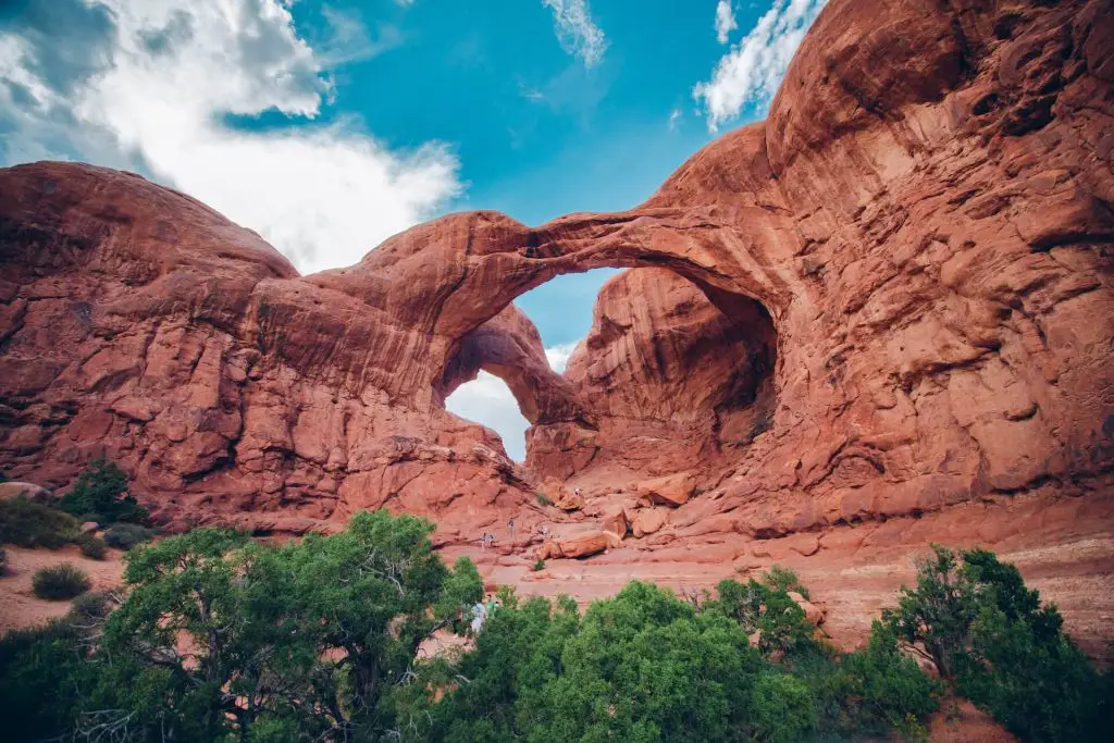
Windows Loop
Distance: 1.2 Mile (loop hike)
Elevation: 154 feet
Difficulty: Easy
Duration: 30 minutes
Trailhead: End of The Windows Road
https://goo.gl/maps/MmaZsK8xC6tSjWDg7
Trail Description:
Before we start, this is an absolute must visit hike when you are here as the hike is easy and the views are unforgettable, just add this to your list and you won’t regret it. This was one of my favorite hikes with high reward and low difficulty. This short and well marked hike features stops at three amazing arches that are all perfectly setup in a loop trail.
During this hike you’ll be able to see the North and South Window Arches which form gigantic openings that create a frame that encloses the Arches National Park landscapes in the background. This trail also features the turret arch which is the smallest arch of the trio, but also worth the visit.
From the parking lot is a well marked dirt trail up some steps before you reach the North Window Arch. From here is another short walk on the dirt path before you reach the South Window Arch. As you make your way clockwise on the trail, you’ll eventually reach the turret arch. Continue clockwise and you’ll eventually return to your original point of origin.
Keep in mind:
With this hike being so easily accessible and having great views of two huge arch windows, this trail is incredibly busy with a ton of other hikers. Ever been to a convention or waited in lines at Disneyland? This is nearly the same feeling, except you’re in the middle of nowhere to escape people and they all followed you. We recommend hiking this very early or late in the day where there is much less people.
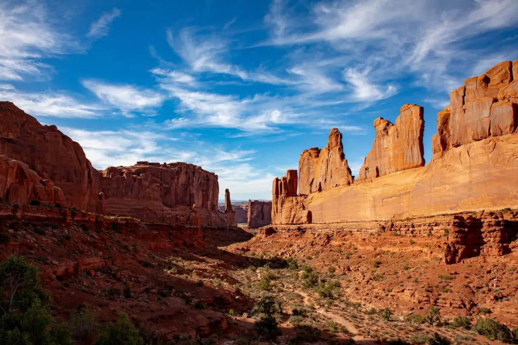
Park Avenue Trail
Distance: 1.8 miles (round-trip)
Elevation: 300 feet
Difficulty: Easy
Duration: 1 hour
Trailhead: Few Minutes from Park Entrance
https://goo.gl/maps/hJcdPwfPzq2pw7aG9
Trail Description:
This trail leads you to views of gorgeous towering sandstone arch formations in the distance and sweeping views of the surrounding area. There is a series of steps that can be a bit challenging for some and the path might be a bit hard to follow with some ambiguous spots. This hike has great views of the canyon and the beautiful rock formations.
Keep in mind:
This trail has minimal sun cover as you will be walking in completely exposed portions of a canyon and open desert. This is also located in a popular part of the park so expect to see many others on the trail. We recommend hiking this either earlier before the heat of the sun is high in the sky or later in the evening to take advantage of cooler temperatures.
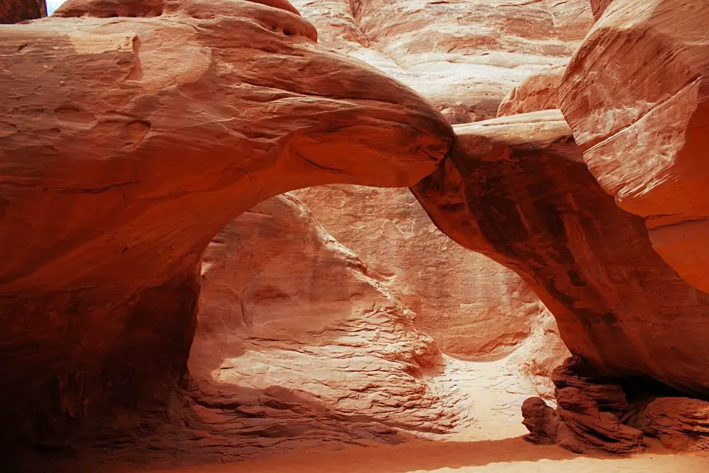
Sand Dune Arch Trail
Distance: 0.3 Miles (round-trip)
Elevation: 100 feet feet
Difficulty: Easy
Duration: 20 minutes
Trailhead: Down the Road from Fiery Furnace and Delicate Arch Trailhead
https://goo.gl/maps/d6ZpnAWH4JUTdabYA
Trail Description:
This trail starts off relatively flat as you make your way up a gradual slope and into a sandy wash. This is a short and easy hike that leads you to a beautiful red and orange sandstone arch. The gorgeous red walls and the soft red sand make it feel like you are on Mars.
Keep in mind:
This trail is also in a popular area of Arches National Park so expect a lot of other hikers on the trail. The arch is located in a small slot canyon so there will be shade provided by the towering rock walls during certain times of the day. We recommend hiking this in early in the morning to avoid the crowds.
Balanced Rock Loop Trail
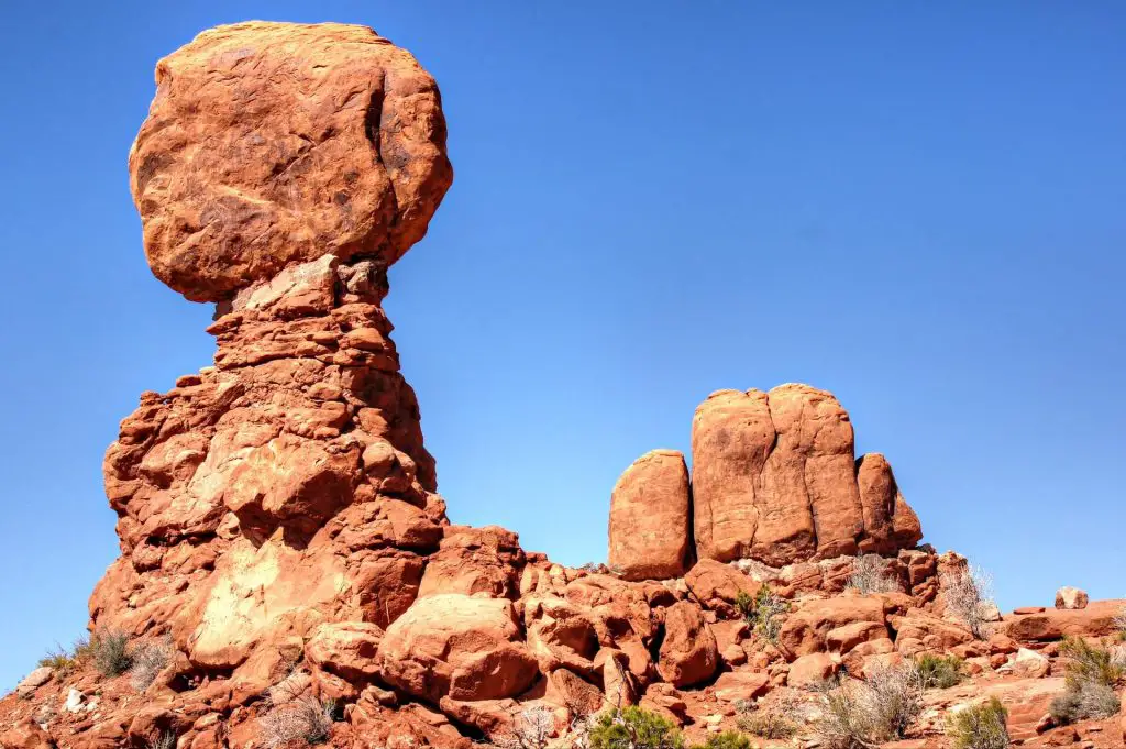
Distance: 0.3 Miles (round-trip)
Elevation: 55 feet
Difficulty: Easy
Duration: 20 minutes
Trailhead: Right before the turn for Double Arch
https://goo.gl/maps/941WaPLkg5bygWXH9
Trail Description:
Balanced Rock Loop takes you up close and personal to this unique rock formation of a massive balancing boulder on a slim sandstone pillar. This quick walk is worth the effort to see balanced rock from directly below and from various different angles.
Keep in mind:
Balanced Rock is located in one of the more crowded areas of the park so expect challenges to find parking and many others on the trail. There is no sun cover on the trail, however it is short so a hat will do the job to provide enough sun cover depending on how how it is.
Wolfe Ranch and Petroglyph Trail
Distance: 0.5 miles (loop)
Elevation: Difficulty: Easy
Duration: 20 Minutes
Trailhead: Delicate Arch Trailhead
https://goo.gl/maps/Qa8bxdsanBKpKkuj6
Trail Description:
To change it up from all of the beautiful sandstone arches, check out Wolfe Ranch and see historical Petroglyphgs on this short 0.5 mile trail. You can add this hike on the end of Delicate Arch for a interesting finish to your hike. This mostly a flat trail with one slight uphill portion and a few minor scrambles.
Keep in mind:
This hike is located in a busy area for hiking so you will definitely encounter other hikers while on this trail. There are some rocky parts at the end fo watch your step. The cabin does a good job of blending in with its surrounding environment so look out for a stack of logs so you don’t miss it!
What Else You Should Know About Arches National Park
What is the best hike in Arches National Park?
The best hike in Arches National Park is its most famous hike, the Delicate Arch trail. This trail will take you deep into the landscape of Arches National Park as you hike from the parking lot, through the dessert, over a rock slab field, and finally to the famous Delicate Arch. The 1.5 miles to the arch is well worth the effort as you will be rewarded with views of the Delicate Arch against the backdrop of the magical Arches National Park landscape. The Delicate Arch is just something else in person and will leave you with a great memory of seeing such a cool natural formation. This hike is rated as moderate and will likely take most an estimated three hours to complete.
How long is the hike at Arches National Park?
There isn’t just one hike at Arches National Park as this park has hundreds of hikes and thousands of miles worth of trails to hike. Arches National Park has some of the best hikes many outdoor enthusiasts can enjoy. The most popular hike for Arches National Park is the Delicate Arch trail which is a 3.1 mile round-trip hike from the Delicate Arch parking lot to the actual Delicate Arch itself. This popular hike is a moderately rated with slight inclines.
Is Delicate Arch a hard hike?
Delicate Arch is moderately difficult as there are some areas with a slight incline, however most people should be able to make the trek out to the Delicate Arch. If you take your time and take adequate breaks you should complete the hike. The trail is very well maintained and well marked, so it is easy to navigate from the start of the trail to the actual arch. Since the Delicate Arch is so famous, there are lots of other hikers on the trail of all ages and fitness levels.
What is the best time of year to go to Arches National Park?
The best time of the year to go to Arches National Park is in the winter time as temperatures are much cooler and there are less people. Hiking the hikes with the red rocks covered in white snow is a serene sight to see and just magical. We would recommend not visiting the park in the Summer as it gets very hot and super crowded. The second best time to visit would be in the late winter or early spring before busy season begins, that way there will be less people on the trails and more peace and quiet for you.
Which is better Zion or Arches?
This is a loaded question and my answer will probably offend many hikers! I think Arches National Park is the better national park due to the unique arch formations that you won’t see anywhere else. The Arches for me were just super cool and I prefer hiking on dirt instead of water.
However, Zion National Park is a fantastic national park and provides much more variety in terms of sights to see and adventures. Zion National Park has hikes that take you to the top of Zion Canyon, hikes into slot canyons through the rivers, and has places where you can canyoneer down into the slot canyons.
Why is Delicate Arch so famous?
Delicate Arch is so famous because it is a unique rock formation that when you see it in person it shouldn’t exist. It looks perfectly crafted and placed into the Arches National Park landscape, however it is completely natural and not man-made. The Delicate Arch has taken million years to form and is the landmark rock formation of the entire mark. The Delicate Arch can also be seen on the Utah license plate and was seen in the 2003 The Hulk Film.