
Canyonlands National Park has hundreds of miles for hikers to explore from all skill levels and ages. From hiking along the rim of the vast canyon to seeing stone arches, Canyonlands has a wide variety of sights and sounds to see during your hikes.
- Mesa Arch – 1.5 miles (out and back)
- Upheaval Dome (First & Second Overlooks) – 1.7 miles (out and back)
- Grand View Point – 1.8 miles(out and back)
- Aztec Butte – 1.8 miles (out and back)
- Whale Rock – 1 miles (out and back)
- Murphy Point – 3.4 miles (out and back)
- White Rim Overlook – 1.8 miles (out and back)
- Green River Great Overlook – 0.2 miles (out and back)
We’ve gathered a list of eight of the best short and easy hikes that you should not miss during your hiking adventure in Canyonlands National Park for the Island in the Sky section. These hikes are all easy hikes that can be completed as quick day hikes and assume a hiking pace of two miles an hour. Be sure to adjust the duration of each hike based on your hiking speed.
Canyonlands National Park Overview
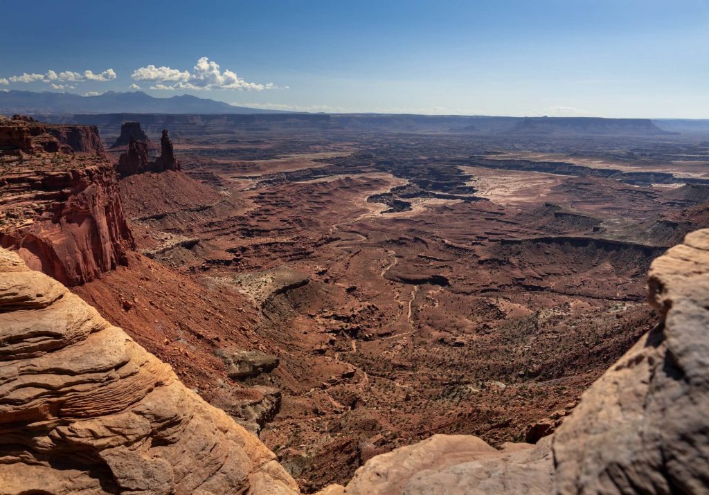
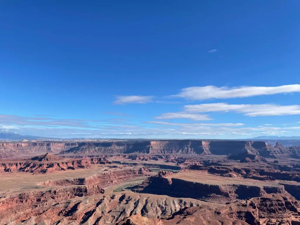
Canyonlands National Park is located in the southeast side of Utah, just 32 miles outside of Moab, Utah. Canyonlands is the largest national park in Utah and features panoramic views for hundreds of miles of the vast canyon carved landscape.
This park is made up of four distinct areas: the Island in the Sky, the Maze, the Needles, and the Green & Colorado. The easiest way to visit this national park and where all of our hikes will be located is the Island in the Sky area.
This park is an absolute must visit when you are visiting Moab, Utah as it provides unforgettable views of the magnificent canyon areas of Utah. This park provides a nice contrast if you just visited Arches National Park as there significantly less arches and more panoramic views of the brown and orange rocky canyons in the vast distance.
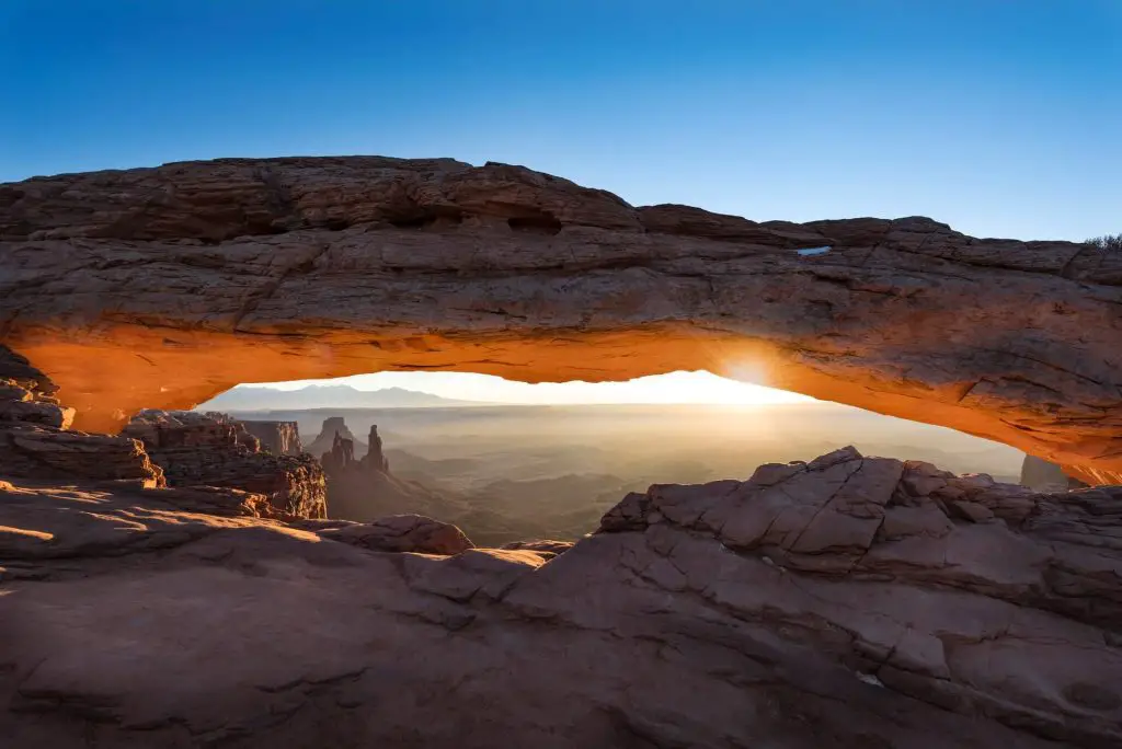
Mesa Arch
Distance: 1.5 miles (out and back)
Elevation: 80 feet
Difficulty: Easy
Duration: 30 minutes to one hour
Trailhead: Mesa Arch Trailhead Parking lot
Trail Description:
This trail features the world famous Mesa Arch that you’ve likely seen on your social media feeds. This is an amazing 50 foot stone arch that dangles over the cliffs that perfectly frames the canyon vistas in the distance. Just below the arch is a cliff face and about a 500 foot drop to the canyon below! This is a well maintained and very popular short 0.7 mile hike from the parking lot with very minimal elevation gain. Once you leave the parking lot, you’ll quickly reach a split in the trail. Take either path as they both lead to the Mesa Arch.
Keep in mind: This trail can be incredibly crowded during sunrise or sunset due to the picture perfect arch and the fantastic canyon views that make an unforgettable sight. If you can head here during the off season in the winter there will be significantly less people and there will be a wonderful mix of the brown and orange canyons covered in a white powdery snow.
Upheaval Dome (First & Second Overlooks)
Distance: 1.7 miles (out and back)
Elevation: 200 feet
Difficulty: Moderate
Duration: 1 hour to 2 hours
Trailhead: At the end of Upheaval Dome Road
Trail Description:
This hike features two viewpoints of the 1,000 foot deep Upheaval Dome crater. You will be able have a close look at this massive crater. It was a mystery to geologists as to how this crater was formed, but theories have suggested that a meteor hit the earth to cause the deep impact into the surface of the earth. The first overlook is 0.3 miles from the trailhead after some stone steps. From here you can choose to continue on the second half of the trail on a not so obvious dirt path. Cairns guide the way as you make your way towards the second overlook.
Keep in mind: This trail has minimal sun cover and most people only head towards the first overlook as the second overlook has very similar views of the crater. By hiking to the first overlook then the hike is just a quick 0.6 mile round-trip hike.
Grand View Point
Distance: 1.8 Miles (out and back)
Elevation: 175 feet
Difficulty: Moderate
Duration: One Hour
Trailhead: Grand View Point Parking lot
Trail Description:
This hike features what it seems like unlimited panoramic views of the vast brown and orange canyonlands. You will see the Colorado and Green Rivers below as you make your way along the rim of the canyon. This hike follows along the edge of the canyon as you make your way down to the southern most tip of the island in the sky. At some parts the trail is not so obvious, so look around for cairns as your guide. Eventually the endless rim comes to a stop leaving you an area to climb and explore to get views in nearly all directions. The short hike lives up to its name and should not be missed.
Keep in mind: As with most trails on this list, this hike is incredibly popular with no sun cover at all. Be mindful of the cairns as the trail becomes ambiguous in some spots with no clear direction. Watch out as you hike along the canyon’s edge as its a long way down.
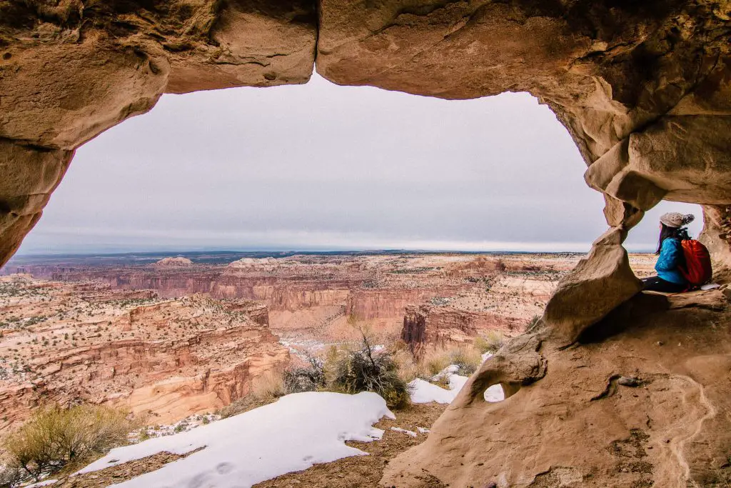
Aztec Butte
Distance: 1.8 miles (out and back)
Elevation: 249 feet
Difficulty: Moderate
Duration: One to Two Hours
Trailhead: Aztec Butte Trailhead (off of Upheaval Dome Road, West of Mesa Arch)
Trail Description:
This hike features the Puebloan granaries which were used as storage by early settlers that look out to awesome views of Taylor Canyon. This 1.8 mile hike has the most variety for a trail for all of the hikes I did in canyonlands as you will be hiking over dirt, the grasslands, ascend up the steep granite slopes as you make your way towards the granaries.
The trail starts off in the grasslands as you make your way 0.25 miles towards the Aztec Butte. From here the real adventure begins where you have to scramble up the main butte. Take your time as this part can be tricky and slippery. You’ll eventually find yourself at the graneries.
Keep in mind: While this short is hike, the section on the aztec butte itself is pretty tricky as you ascend quickly up some rocky slopes. One of the graneries has a window next to it that provide great photos as you peer out towards Taylor Canyon. This unique hike in canyonlands is well worth it and a great adventure packed into such a short hike.
Whale Rock
Distance: 1 mile (out and back)
Elevation: 255 feet
Difficulty: Moderate
Duration: 1 hour
Trailhead: Whale Rock Parking Lot (fits 10 cars)
Trail Description:
This hike features panoramic views of the brown and orange canyonlands in the distance and a fun scrambling adventure as you make your way up the tail of the whale. There are cemented cairns in place that help guide hikers and even some railings to help you make your way up. This hike is rated as moderate as there are some slippery parts of the trail when trying to move up the slick sandstone. This is a fun hike to do and a good change of pace.
Keep in mind: The sides of the whale are much too steep to climb, so be very careful and stay on the trail. This trail also has no sun cover whatsoever so I suggest hiking it earlier in the day to avoid the heat. Since this trail is so short and easily accessible that means it will attract large crowds, so the trail can feel very busy.
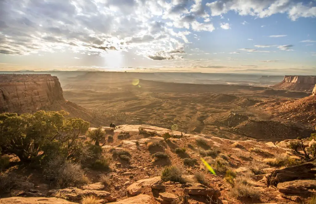
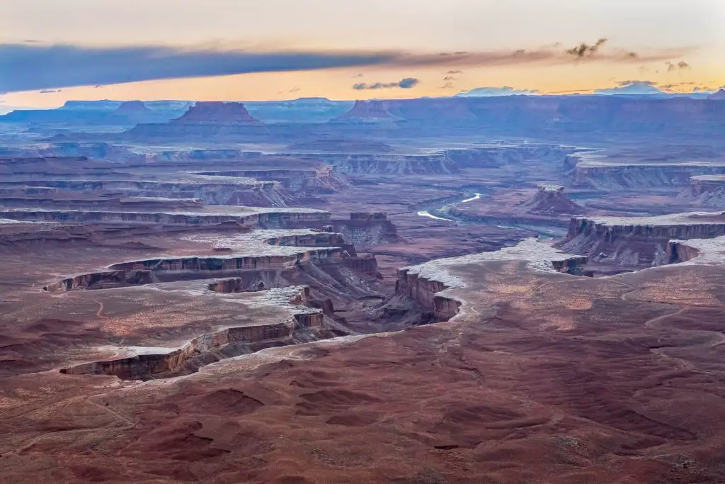
Murphy Point
Distance: 3.4 miles (out and back)
Elevation: 150 feet
Difficulty: Moderate
Duration: 2 hours
Trailhead: Just South of Mesa Arch, west of the Grand View Point Road is a tiny round about that fits maybe 10 cars.
Trail Description:
Murphy Point features near panoramic views of the southern side of the Island in the sky. You’ll be able to see Still Water Canyon with Green River flowing right through. This short hike begins on a descent down an orange dirt path as you make your way towards the stone trail that guides you with scattered cairns. From here you can see just how the Green River has carved out the canyon walls and will be able to see Grand View Point in the distance.
Keep in mind: Since this is a westward facing trail we highly recommend you hike this during sunset as the amazing colors will paint an unforgettable canyon land vista. There are very little spots to park in the roundabout, so keep that in mind when planning this hike. There is also no sun cover, so high this early when temperatures are lower or bring plenty of sun cover such as a hat and long sleeves.
White Rim Overlook
Distance: 1.8 Miles (out and back)
Elevation: 165 feet
Difficulty: Moderate
Duration: 1 to 2 hours
Trailhead Small round about off Grand View Point Road with a few parking spots next to the picnic areas and some off the road parking.
Trail Description:
White Rim Overlook features grand views of the eastern side of the Island in the Sky. While the hike is short, the views are grand. The quick one mile trail follows the canyon rim where the cliffs drop hundreds of feet just a few steps off the trail in some parts. Each step has amazing views of the seemingly never-ending White Rim, the rivers carved by the Colorado River below, and the Monument Basin in the south.
The trail begins on gravel, however eventually the path becomes less obvious as cairns guide you until you can’t hike any more. You’ll be able to take in the panoramic views of the White Rim making you feel like you teleported to another planet.
Keep in mind: There are very few parking spots for this trailhead as the picnic areas can be busy with hungry hikers taking a break. The is little signage on the trail so be on the look out for cairns and be careful when taking photos near the canyon’s cliffs. Since this is an eastern facing trail, we highly recommend you hike it during sunrise as you will be able to see an amazing mix of golden hour colors setting over the dramatic canyon landscapes below.
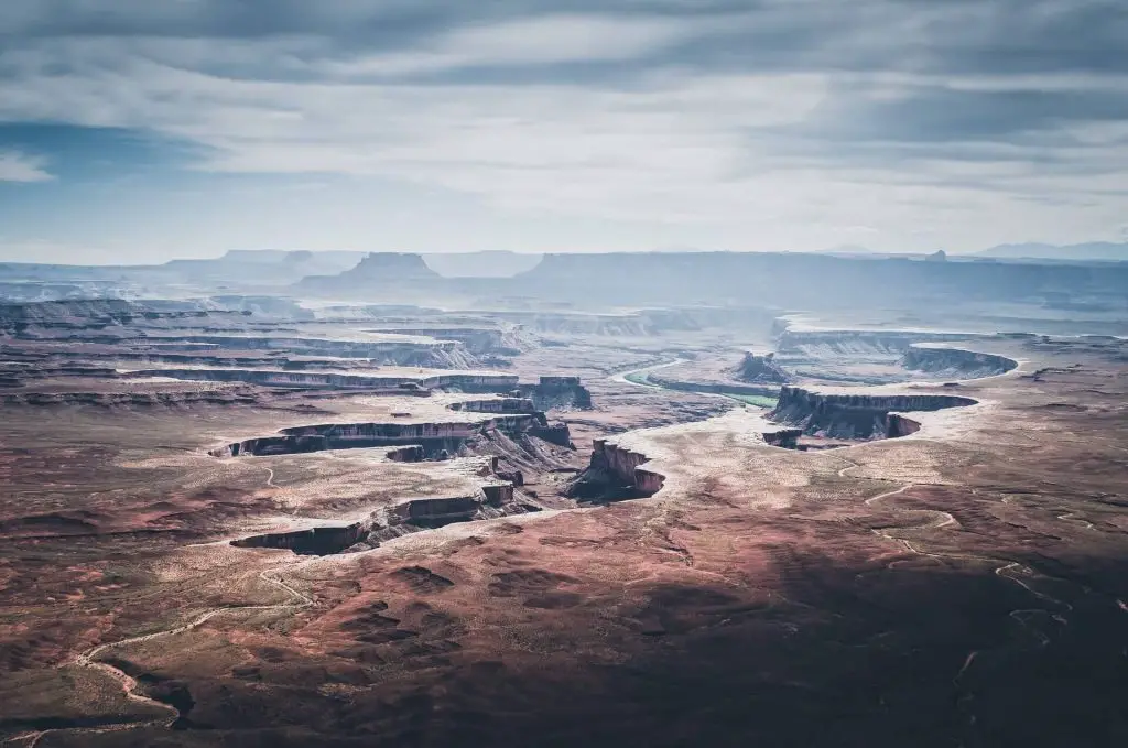
Green River Great Overlook
Distance: 0.2 miles (out and back)
Elevation: 5 feet
Difficulty: Easy
Duration: 10 minutes
Trailhead: Parking Lot at the end of Green River Overlook Road
Trail Description:
Green River Great Overlook is more of a walk than a hike at just 0.2 miles from the parking lot, this is a hike for all skill levels. Although this walk is short, the views are definitely worth a stop as you soak in the sweeping canyon landscapes that the Green River has crafted over many lifetimes.
Keep in mind: This is a great overlook with magnificent views of the Green River and the mesa down below. This is a great stop for a break in between other hikes.
Relevant Questions Section(s)
What can you not miss in Canyonlands National Park?
The things you cannot miss as a new visitor to Canyonlands National Park are the Mesa Arch, Grand View Point, White Rim Overlook, and Green River Great Overlook. At Mesa Arch you will see an amazing 50 foot stone arch hovering over the canyon land vistas. Grand View Point offers sweeping views of the southern side of the Island in the Sky. White Rim Overlook will give you grand views of the eastern side of the canyons. Green River Great Overlook will give you fantastic views of the green river carving its way through the landscape.
How much time do you need to see Canyonlands National Park?
In order to see all of the best views and allocate enough time for the best hikes in Canyonlands National Park, I recommend you designate two full days to see the park. Two days will give you enough time to hike the best hikes at a leisurely pace all while creating unforgettable hiking memories. With two days you can hike around five to eight miles each day without feeling too exhausted or rushed.
Which part of Canyonlands is best?
The part that is the best and most visited is the Island in the Sky district of Canyonlands. This is the most easily accessible part of the park and features vast views of the canyon cliffs and rivers below. At the Island in the sky you can see the Mesa Arch, the 50 foot stone arch that floats above the canyons, boundless views at White Rim Overlook, Grand View Point, and Murphy Point. There are hikes for all ages and skill levels.
Which is better Canyonlands or Arches?
Arches National Park is the better National Park due to having a larger variety of hikes and sights. Arches National Park has hundreds of arches you can hike to that have a variety of formations and distinct characteristics. Canyonlands has much less variety in terms of viewpoints at the end of the hike since most of the hikes lead to views of different sides of the canyon.
How do I spend a day in Canyonlands?
If you only have a day in Canyonlands we highly recommend you hike Mesa Arch(1.5 miles), White Rim Overlook (1.8 miles) , Grand View Point (1.8 miles), and Green River Lookout (0.2 miles) for a total of 5.3 miles of hiking. These trails will lead you to the best view points of the expansive canyonland views. If you are wondering how much it cost to enter, check our our post here.