
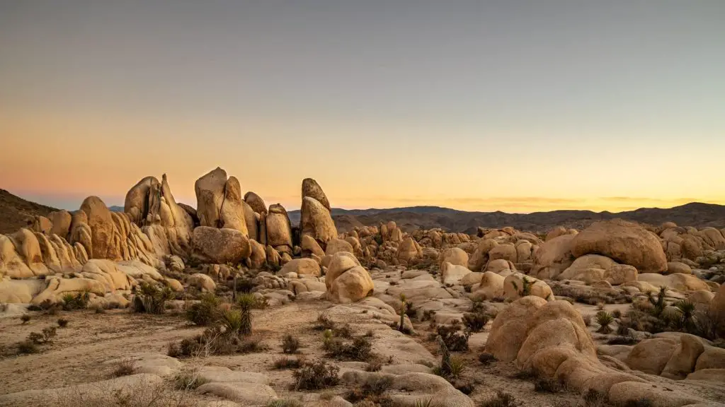
While Joshua tree may first seem like a desert wasteland, it is actually filled with life and many trails to hike for all adventure seekers. This park features trails that will take you to desolate dessert landscapes, a rocky wonderland of boulders, bone-dry stone peaks, and more. I’ve gathered a list of 8 of the best short and easy hikes in Joshua Tree National Park that you should absolutely do. You’ll be able to see grand views of Joshua Tree as you climb up the rocky peaks, a palm filled dessert oasis, a giant skull, and much more.
- Hidden Valley Nature Trail – 1 mile (loop)
- Ryan Mountain Trail – 3.0 miles (out and back)
- Barker Dam Nature Trail – 1.5 miles (loop)
- Forty-nine Palms Oasis Trail – 3.1 miles l (out and back)
- Arch Rock Nature Trail – 1.3 miles (loop)
- Skull Rock Nature Trail – 1.8 mile (loop)
- Mastodon Peak Loop Trail – 2.6 mile (loop)
- Wall Street Mill Trail – 2.6 mile (loop)
Joshua Tree National Park Overview
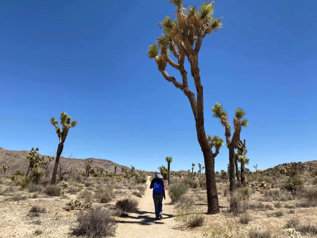
Joshua Tree National Park is located in south east of California. This area of this park is where the Mojave dessert meets the Colorado dessert and is home to distinct Joshua Trees (a type of Yucca).
Joshua Tree is a rugged high dessert landscape featuring dessert fauna, rocky trails with huge boulders, and the vast dessert plains sprinkled with Joshua Trees. This park is a great getaway for hikers for adventures out in the dessert. This clash of the two dessert areas creates for a unique mix of sights to see on your hikes.
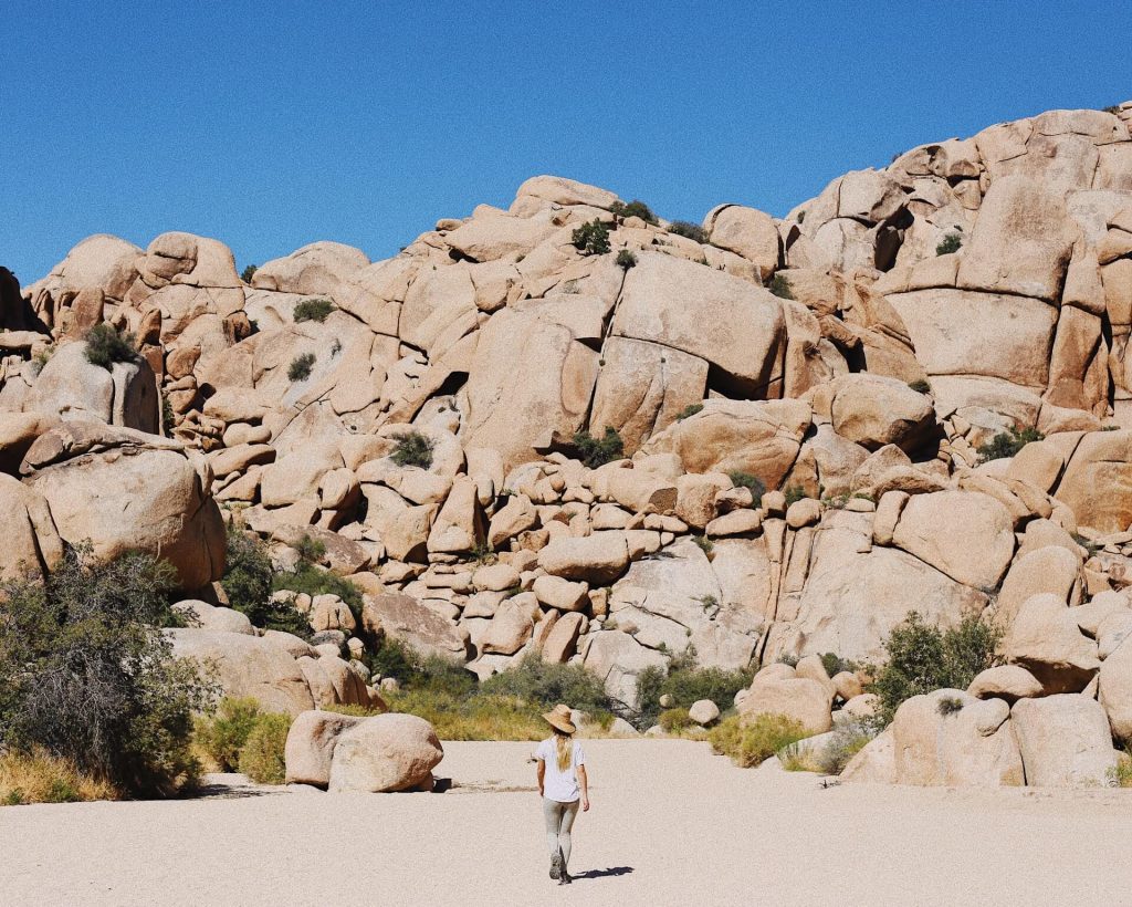
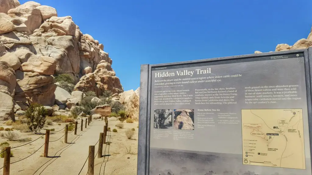
Hidden Valley Nature Trail
Distance: 1 mile (loop)
Elevation: 75 feet
Difficulty: Easy
Duration: 30 minutes
Trailhead: Hidden Valley Parking Area loop
Trail Description:
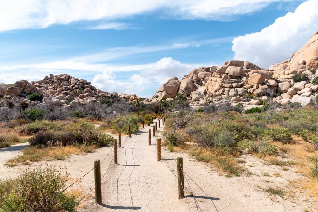
This short 1 mile hike introduces you to the fauna and boulder covered dessert landscape of Joshua Tree. As you work your way around the loop there are boulders calling your name to climb and explore. From the parking lot there are two boulders that create an entrance into the rocky wonderland. Eventually you will reach a t-junction where the loop begins. Choose either path of the loop. There are signs that help identify the various fauna. With just 75 feet in elevation gain the trail is relatively flat with a few rocky scrambles.
Keep in mind: This is an incredibly popular hike as it is quite short, so during busy season the parking spots do fill up fast. Being an open dessert hike, there are no trees for sun cover, however a few huge boulders do provide some much needed shade. With this in mind, be sure to bring enough water and sun cover.
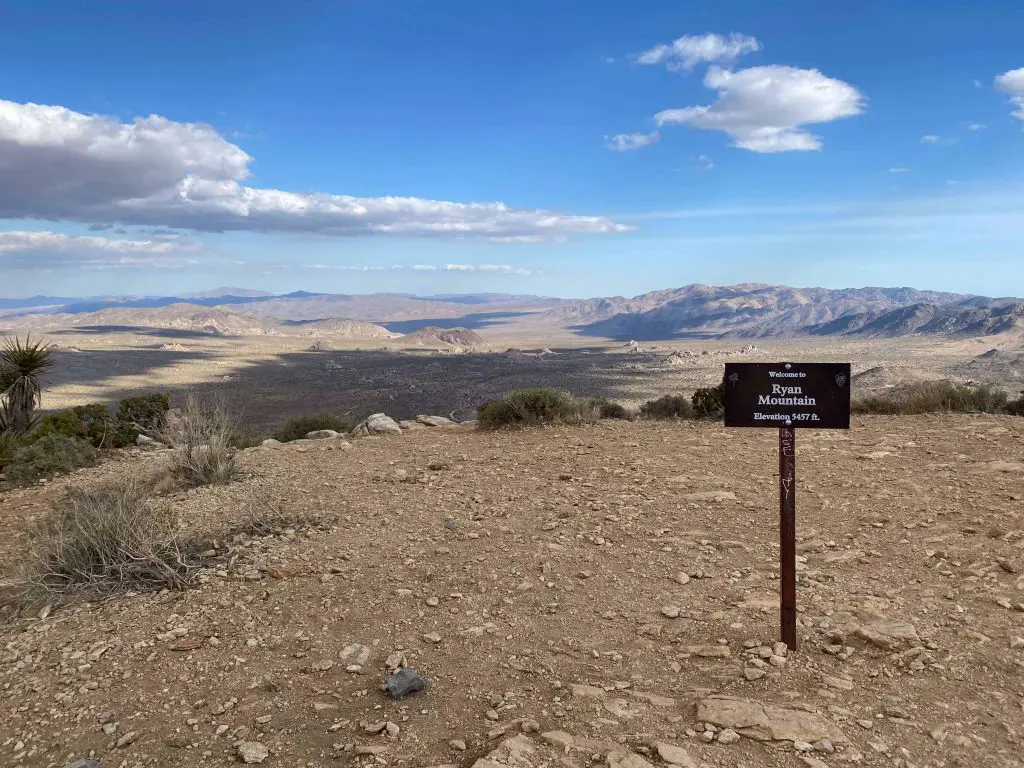
Ryan Mountain Trail
Distance: 3.0 miles (out and back)
Elevation: 1,069 feet
Difficulty: Strenuous
Duration: Two hours
Trailhead: Ryan Mountain Trail Parking Lot (off of Park Blvd)
Trail Description:
This trail is straight to the peak of a 5,457 foot mountain and will take you to the center of Joshua Tree National Park where you can get panoramic views at the peak. This is a strenuous hike as you gain over 1,000 feet in elevation gain in just 1.5 miles. You will be ascending up the trail, climbing over slippery granite and over stone steps.
As you make your way up the mountain, you will encounter just one junction that leads to the Sheep Pass Camp, however stay to the right and head for the peak. From the top you’ll be surrounded by the dessert vistas down below and the jagged rocky formations made up of huge boulders. You’ll be able to see San Bernadino Mountains on the horizon.
Keep in mind: This is a very popular hike and the trail can get incredibly crowded. There is also no sun cover at all on the trail, so hike early and bring sun protection. All of the elevation gain is on the way up to the summit and its all down hill from the peak.
Barker Dam Nature Trail
Distance: 1.5 miles (loop)
Elevation: 60 feet
Difficulty: Easy
Duration: 45 minutes
Trailhead: Small Parking lot off Queen Valley Road
Trail Description:
The Barker Dam Nature Trail takes hikers to a water reservoir on a short well marked hike. Being in the middle of the dessert this water reservoir seems like a mirage of an oasis like the ones you see in movies or television shows. Be sure to visit this hike during spring or winter time as the water completely disappears in the summer and fall. From the parking lot head east and work your way clock wise, but be sure not to accidentally take the Wall Street Mill trail. Follow the sandy trail clockwise until you reach the waters of the dam.
Keep in mind: Since this is a water reserve in the middle of the dessert, the water can evaporate during dry season and you’d be wondering why this is called Barker Dam when just looking at dry dessert ground. There is no shade on this trail and it can get very hot during the day.
Forty-nine Palms Oasis Trail
Distance: 3.1 miles l (out and back)
Elevation: 350 feet
Difficulty: Moderate
Duration: 2 hours
Trailhead: Parking lot that fits about 25 cars at the end of Forty-nine Palms Canyon Road
Trail Description:
This hike will lead you to a dessert oasis that is surrounded by a grove of palm trees. After looking at the dry dessert landscapes and rocky surroundings, you wouldn’t believe that a group of palm trees would be able to survive in this desolate environment. The trail from the parking lot leads you uphill on an established hiking trail. As you ascend up you’ll be able to soak in views of the dessert down below. At around 0.7 miles you’ll start descending towards the cluster of Palm trees. Once there you can enjoy some much needed shade and listen for the flowing water if you’re lucky.
Keep in mind: This hike is on the outskirts of the park at the north end, so allocate some time for the drive. The trail is very rocky and has minimal sun cover, so bring plenty of water and hike earlier in the day.
Arch Rock Nature Trail
Distance: 1.3 miles (loop)
Elevation: 100 feet
Difficulty: Easy
Duration: 20-30 minutes
Trailhead: Parking lot off Pinto Basin Road
Trail Description:
This is one of the best hikes in Joshua Tree National Park as it features a very cool 30-foot natural stone arch. This short well established hike will lead you to the rocky formations that surround the White Tank Campground. If you’re lucky enough to get a campsite at White Tank Campground, the loop is just 0.2 miles, however for most hikers you’ll begin at the parking lot off of Pinto Basin Road. From the lot you’ll do a brief hike through the dessert before reaching Pinto Basin Road. Look both ways and cross the street as you hike down the hill to White Tank Camp Ground. Once you reach the campground you’ll follow a 0.2 mile loop towards Arch Rock.
Keep in mind: There are no extra parking spots at White Tank Campground, so park at the lot off Pinto Basin Road. Be very careful when crossing the Pinto Basin Road. Be sure to bring plenty of sun protection as this trail has no shade.
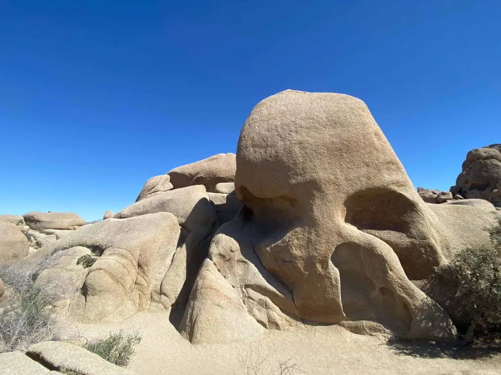
Skull Rock Nature Trail
Distance: 1.8 mile (loop)
Elevation: 120 feet
Difficulty: Easy
Duration: 1 hour
Trailhead: Jumbo Rocks Campground
Trail Description:
The Skull Rock hike will take hikers though giant rock and past dessert washes. Hikers will be able to see the large variety of dessert fauna and rocks that look like faces and of course the main feature the giant Skull Rock. The main trail starts at Jumbo Rocks Campground and heads in a clockwise direction.
You’ll encounter a boulder field before you reach the dessert wash. There will be some bouldering sections and a small hill climb before you descend towards Park Blvd. Continue on the trail and you’ll be able to explore the rocky wonderland.
Keep in mind: This trail is very popular so I recommend hiking it earlier as it will be cooler and have less people. You can technically hike the opposite direction from Jumbo Rocks Campground and have a significantly shorter hike to reach Skull Rock, however I recommend hiking the entire hike to be able to see the crazy rock formations and dessert landscape!
Mastodon Peak Loop Trail
Distance: 2.6 mile Loop
Elevation: 440 feet
Difficulty: Moderate
Duration: 1 to 2 hours
Trailhead: Cottonwood Oasis Road
Trail Description:
Mastodon Peak hike features panoramic view of the Joshua Tree landscape. This trail will take you up to Mastadon peak where you will be able to see the variety of dessert plants mixed in with the rocky boulders. Towards the end of the hike the trail gets a bit more ambiguous and you’ll have to find cairns for your guide. The end of the hike is a giant boulder pile that you’ll have to scramble your way up. The end presents you with 360 degree views of Joshua Tree with the yellow and brown boulder fields in the distance.
Keep in mind: Since this trail is very popular, hiking can be incredibly limited. The main thing to watch out for is the last part of the trail where the trail isn’t as obvious, so be on the look for the cairns to help you finish the hike.
Wall Street Mill Trail
Distance: 2.4 miles (out and back)
Elevation: 90 feet
Difficulty: Moderate
Duration: 2 hours
Trailhead: Off Queen Valley Road
Trail Description:
This trail features a visit to the past where you’ll see a gold mill that miners used to try to find gold and silver from the Joshua Tree land. You’ll be able to see the blueprints for this gold mill, an old well pump and the decaying gold mill. From the Wonderland of Rocks Trailhead you’ll hike past the bathrooms until you reach a trail split. Continue on to the right path towards the Wall Street Mill. The end of the hike leads you right to the old gold mill and you’ll wonder how much gold they actually found.
Keep in mind: There are technically two starting points for this trail. If you hike from the Wonderland of Rocks it will be the full 2.4 mile distance, but if you start the hike at the Queen Valley Road gravel road then you can cut the hike short by about .6 miles, however there is limited parking there.
Relevant Questions Section(s)
What are the best hikes in Joshua Tree?
The best hikes in Joshua Tree are Barker Dam Nature Trail, Ryan Mountain, and Skull Rock Trail. These are all short day hikes that can be completed in a few hours and take you on an adventure through boulder fields, dessert cacti and flowers, and to panoramic views of the expansive Joshua Tree landscape vistas. There are the can’t miss hikes that new hikers should not miss and give you the main highlights of Joshua Tree National Park. If you are starting to plan your trip, check out our post on what the entrance fee of Joshua Tree is to help with your budgeting.
Where can I hike in Joshua Tree?
There are many well established trails in Joshua Tree that you can hike. We recommend hiking the Barker Dam Nature Trail, Ryan Mountain, and Skull Rock at a minimum. These hikes will give you the highlights of Joshua Tree, taking you from the boulder fields down below to the top of the dessert to get sweeping views of the Joshua Tree dessert landscape. These hikes are all under three miles and can be completed within a day.
How long is the Joshua Tree Hike?
There isn’t just one hike in Joshua Tree, however the most popular hikes for this park are Ryan Mountain, Skull Rock, and the Hidden Valley Trail. These hikes vary in length from 3 miles to as short as one mile. Most of these hikes have no shade and are in a dry dessert area, so be sure to bring sun protection and enough water for your hikes.
Do you need hiking boots for Joshua Tree?
We recommend bringing hiking boots for your hikes in Joshua Tree due to the changing landscape throughout the various hikes. Hiking boots will give you much better grip while your are working your way up stone steps and scrambling up giant boulders. The boots will also protect your feet from being scratched from the numerous cactus scattered throughout the trails. Check our our post to see if you really need hiking boots.