
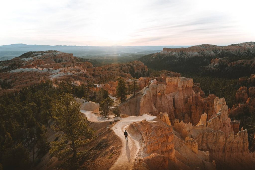
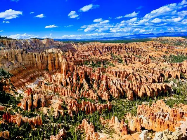
The great pink and red orange vistas provide many amazing hikes that will take you from the top of the canyon to deep into the canyon floor below where you can walk among the towering hoodoos. There are many loop hikes that will take you across multiple trails bringing you up close and personal with Thor’s Hammer, The Queen, and much more! Bryce Canyon National Park is fantastic for hikers of all skill levels and is a must visit when you are touring the Southwest side of Utah. These 8 hikes will give you the best sights that Bryce Canyon has to offer! While most of these hikes may seem long in miles, they are moderate trails and can be done by most. You can choose to hike entire loops or split the hikes into shorter distances and still see the best that Bryce has to offer.
Bryce Canyon National Park Overview
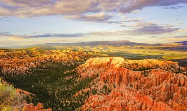
Bryce Canyon National Park is located in Southwest part of Utah off of the Utah 63. Bryce Canyon National Park is known for its red, orange and pinkish vistas shaped by its infamous Hoodoos(rock columns). Bryce Canyon is located at the top of the Grand Staircase, sitting between 8,000 feet to 9,000 feet in elevation. This means during the wintertime you will get a wonderful sight of white snow mixed with the pink and red landscape, setting up for unforgettable sights. If you ever wondered what a crater on Mars would look like, this would be exactly what you would imagine. Bryce Canyon is a great destination for hikers and outdoor enthusiasts.
Navajo Loop Trail
Distance: 1.5 Miles (loop)
Elevation: 515 feet
Duration: 1.5 hours to 2 hours
Difficulty: Easy
Trailhead: Sunset Point Shuttle Stop
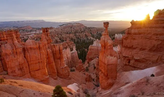
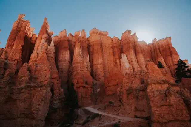
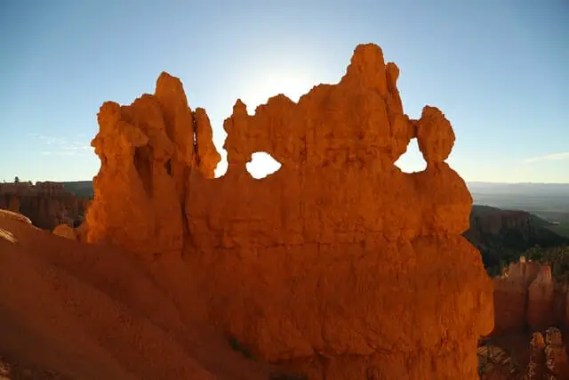
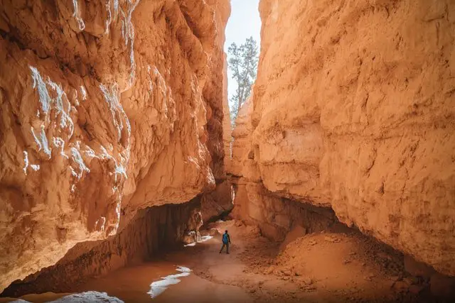
Trail Description: This trail will take you to see the famous park features such as Thor’s Hammer, Twin Bridges, and Wall Street. This trail starts at Sunset Point and hikers will make their way down to the bottom of Bryce Canyon on a steady decline. The trail will continue down and as you descend switchbacks. Eventually the trail will flatten out and you will make your way up some switchbacks as Wall Street towers over you. A cool sight to see is two huge fir trees that seem like they have no business growing where they are, but make for great photo opportunities as you see the canyon divide above. As you finish the hike upwards, you will be able to see the Twin bridges just as you make your way towards the rim. Right before the last leg of the trail, keep an eye out for Thor’s Hammer!
Keep in mind:
This hike can be very hot and dry in the summer, so wear sun protection and bring enough water. If you’re hiking in the winter, bring micro spikes as the switchbacks can be incredibly slippery.
Fairyland Loop Trail
Distance: 7.8 Miles (loop)
Elevation: 1,545 feet
Duration: 4 to 5 hours
Difficulty: Moderate
Trailhead: Fairyland Point (north of the Visitor Center with a parking lot)
Trail Description:
This hike will take you from the upper rim of Bryce Canyon and descends you into the canyon down below. You will be able to see spectacular views of the top of Hoodoos below as you start the hike. As you reach the lower regions of the canyon, you will be surrounded by the pink and orange walls as hoodoos tower over you giving you a whole new perspective. This trail features a variety of sights and views and will give you up close and personal views of the hoodoos. As you ascend from the bottom of the canyon up the ridge, you will see more beautiful views from above.
Keep in mind: This trail is well maintained, but since it is a loop and intersects with other loop hikes, watch out for the signs and trail split offs. This trail also has minimal cover from the sun, so wear protective gear during your hike to stay cool. If you’re hiking this in the summer then expect many others on the trail, so its best to hike earlier when temperatures are cooler and there are less people. Hiking this in the winter time is also a great experience as you will see the mix of snow and red orange rock. We advise bringing micro spikes to help with grip as the trail can get icy at some parts in the winter. This hike starts off with a quick descent into the canyon floor and most of the elevation gain is made up on the 4th mile.
Sunset Point to Sunrise Point
Distance: 1.1 Miles (there and back)
Elevation: 82 feet
Duration: 30-40 minutes
Difficulty: Easy
Trailhead: Sunset Point
Trail Description:
This is a popular paved and flat hike along the rim of the canyon which overlook beautiful views of the hoodoo filled canyon below. As you hike along the rim, you will be able to see sweeping vistas of the orange and pink canyon with of the infamous sea of Bryce Canyon Hoodoos that take over the landscape that stretch on.
Keep in mind: This trail is very popular as it is one of the more accessible trails in the park, so keep in mind. Also watch out for the Sunrise Point sign as this hike is part of the rim to rim trail that goes on for miles and miles.
Mossy Cave Turret Arch and the Little Window Trail
Distance: 1 Mile (there and back)
Elevation: 120 feet
Difficulty: Easy
Trailhead: Small Parking lot off the Highway 2
Trail Description:
A short and sweet hike located outside of the main amphitheater that takes you to a small cave and a hidden waterfall. This trail also features walking along the hoodoos, window arches in the rock formations, and more. After seeing hoodoos and rugged rock formations, Bryce Canyon surprises hikers with the sights and sounds of a flowing waterfall. After the waterfall are the window formations that pierce through the red orange rock wall.
Keep in mind: Since this trail is near flowing water, it can get very icy during the winter time, so bring micro spikes to help with shoe grip otherwise it will be very slipper and dangerous. If you are hiking during the summer time then bring enough water and sun cover to help from the intense sun.
Queen Victoria via Queen’s Garden Loop
Distance: 2.1 Miles (There and back)
Elevation: 405 feet
Difficulty: Moderate
Trailhead: Sunrise Point
Trail Description:
This hike features a rock formation that is shaped like the Queen Victoria. If you only do one hike in Bryce Canyon, this is it. This hike starts off with a 320 foot descent from the canyon rim down into the lower canyon. During this hike you will see many multi-color hoodoo rock formations, towering canyon walls, and amazing views. This hike can be added as part of the larger Queens Garden Loop.
Keep in mind: This is one of the most popular trails in the park, so expect a lot of other hikers on the trail. We recommend hiking this earlier in the day as there will likely be less people and temperatures will be much cooler. If you’re hiking this in the winter, watch out for trail closures.
Wall Street and Queens Garden Loop to Peekaboo Loop (Figure Eight Trail)
Distance: 6.3 miles (round-trip)
Elevation: 1,499 feet
Duration: 4 to 5 hours
Difficulty: Moderate to Strenuous
Trailhead: Sunrise Point
Trail Description:
An absolutely stunning trail that wraps the best that Bryce Canyon has to offer in a figure eight trail that combines the two best hikes in the park Queens Garden Loop and Peekabook Loop. This trail will take you from the stunning vistas of the Bryce Canyon Amphitheater above to the numerous hoodoo rock formations. You see the towering Wall Street hoodoos, rock windows, the queen, and many other amazing views. This hike should be done clockwise from Sunrise Point down into the canyon with the Queens Garden section first all the way to the Peekaboo Loop, ending with the switchbacks near Wall Street.
Keep in mind: This hike is long and there are many other trails that intersect these loops, so watch out for the trail signs. The end of the hike is where most of the elevation gain is, so take your time as you make your way up the switchbacks.
Tower Bridge Trail
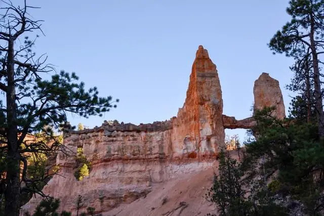
Distance: 3.4 Miles (round-trip)
Elevation: 826 Feet
Duration: 2 hours
Difficulty: Moderate
Trailhead: Sunrise Point
Trail Description: This trail is generally added on-top of the Fairyland Loop Trail. Halfway through this hike features the stunning Tower Bridge that resembles the London Tower Bridge. The first half of this hike is a quick descent from the rim of the Canyon at Sunrise Point until you reach the half way point of the Tower Bridge. Once you reach tower bridge you have the option to continue on to the rest of the Fairyland Loop.
Keep in mind: This trail descends quickly and the elevation gain is all on the way back as you ascend towards Sunrise Point. If you have the time we recommend you hike this during sunrise as you will see an amazing mix of colors and see the hoodoos transform as the sunrises over the canyon.
Bristlecone Loop Trail
Distance: 1.0 mile
Elevation: 88 feet
Difficulty: Easy
Trailhead: Rainbow Point
Trail Description:
A nice walk in the woods to see the 1,800 year old bristle cone pines at the tallest point in the park sitting at 9,000+ feet. This hike is a nice change of pace if you want to see pines next to hoodoos and the red and pink rock formations of Bryce Canyon. You will be surprised to see how far the hoodoos stretch outside of the main amphitheater.
Keep in mind: This is a good warm-up hike for bigger hikes in the area, but still a nice and relaxing stroll in Bryce Canyon.
What is the best hike in Bryce Canyon?
Bryce Canyon offers hundreds of miles of hiking for hikers of all ages and skill levels, however if it is your first time to Bryce Canyon, the best hike to do is the Queens Garden Loop to Peekaboo Loop(Figure Eight Trail) which is listed above. This trail encompasses a majority of the main attractions of Bryce Canyon National Park. You will be able to view the serene amphitheater of hoodoos from above the canyon rim and will be transported down below to the canyon floor to get up close and personal with these magical rock formations. This hike is the best hike in Bryce Canyon and an absolute must do if you have the time for it. If you are short on time then the 2.1 mile hike to see the Queen Victoria is also one of the best hikes to do as you will also be able to see the overview of the canyon and venture down below.
What should I not miss in Bryce Canyon?
Bryce Canyon National Park has so many amazing features and hikes, but we understand if you are limited on time, so the things you should definitely not miss in Bryce Canyon are seeing the Wall Street of hoodoos, Thor’s Hammer, and walk along the rim from Sunset Point to Sunrise Point or in reverse. These sights should not be missed and will give you the quintessential Bryce Canyon experience.
What do I need to hike in Bryce Canyon?
In order to enter Bryce Canyon National Park, you need to purchase a car permit from the rangers as you drive through the park’s entrance. For your hikes we highly recommend you to have shoes with good grip, sun cover such as a hat and sun glasses, enough water for yourself, and snacks! If it is winter time be sure to bring micro-spikes so you can get more secure footing. We also recommend you bring a flashlight or headlamp in case your hikes take longer than expected.
Which is the best Zion or Bryce Canyon?
Both of these National Parks located in the southwest part of Utah offer amazing and very different experiences. Bryce Canyon is known for its famous hoodoo rock formations with their pink and orange color. Zion National Park on the other hand has much more variety in terms of hikes. You can hike up above and see the canyon’s of Zion down below through Angel’s landing, or you can go canyoneering and explore the Subway tunnels. Zion National Park also has the famous Narrows where you walk through a river to explore the magical slot canyons. Each park is very different, but if you have more time we would recommend you visit Zion National Park as there is a greater variety.